
Ficheiro:Last scan of Typhoon Mawar on PGUA.jpg

Dimensões desta antevisão: 800 × 393 píxeis. Outras resoluções: 320 × 157 píxeis | 640 × 314 píxeis | 1 024 × 503 píxeis | 1 920 × 943 píxeis.
Ficheiro original (1 920 × 943 píxeis, tamanho: 580 kB, tipo MIME: image/jpeg)
| Este ficheiro vem do Wikimedia Commons e pode ser usado por outros projetos. Sua página de descrição é reproduzida abaixo. O Commons é um repositório de ficheiros sob licença livre. Saiba como ajudar. |
Descrição do ficheiro
| Descrição |
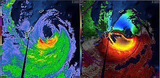
English: The last NEXRAD radar scans of Typhoon Mawar on PGUA. The left side shows NEXRAD reflectivity and the right side shows NEXRAD velocity. |
| Data | |
| Origem | NEXRAD - PGUA |
| Autor | National Weather Service |
Licenciamento
This image is in the public domain because it is from one or more of the U.S. government’s 159 NEXRAD radars, which are jointly owned and operated by the National Weather Service (NWS), an agency of the National Oceanic and Atmospheric Administration (NOAA) within the United States Department of Commerce, the Federal Aviation Administration (FAA) within the Department of Transportation, and the U.S. Air Force within the Department of Defense.
Thus all NEXRAD images are public domain.
|
  |
Histórico do ficheiro
Clique uma data e hora para ver o ficheiro tal como ele se encontrava nessa altura.
| Data e hora | Miniatura | Dimensões | Utilizador | Comentário | |
|---|---|---|---|---|---|
| atual | 04h20min de 24 de maio de 2023 | | 1 920 × 943 (580 kB) | WeatherWriter | Uploaded a work by National Weather Service from NEXRAD - PGUA with UploadWizard |
Utilização local do ficheiro
A seguinte página usa este ficheiro:
Utilização global do ficheiro
As seguintes wikis usam este ficheiro:
- Uso no domínio en.wikipedia.org
- Uso no domínio pt.wikipedia.org
- Uso no domínio zh.wikipedia.org