
Ficheiro:Fires along the Rio Xingu, Brazil - NASA Earth Observatory.jpg

Ficheiro original (1 440 × 960 píxeis, tamanho: 329 kB, tipo MIME: image/jpeg)
| Este ficheiro vem do Wikimedia Commons e pode ser usado por outros projetos. Sua página de descrição é reproduzida abaixo. O Commons é um repositório de ficheiros sob licença livre. Saiba como ajudar. |
Descrição do ficheiro
| Descrição |
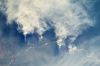
English: The rainforest of South America, also known as Amazonia, has been undergoing a continual and accelerated conversion process into farmlands (including pasture for livestock) since the early 1960s. This process has typically been achieved by clearing the forest using fire—“slash and burn”—followed by planting of crops. The generally infertile soils of this rainforest—the largest such forest on Earth—make sustainable farming difficult. This drives people to convert more forest into farmland. The area of clearing can be considerable, and since the deforested regions are easily identifiable and measurable from space, the rate of deforestation is likewise easy to track.
This astronaut photograph illustrates slash-and-burn forest clearing along the Rio Xingu (Xingu River) in the state of Matto Grasso, Brazil. The photo was taken from the International Space Station, a platform from which astronauts can capture images of the Earth from a variety of viewing angles. The perspective above shows both the horizontal position and the extent of the fire lines next to the river, while also providing a sense of the vertical structure of the smoke plumes. Light colored areas within the river channel are sand bars, which show that the river is in its annual low-flow/low-water stage. For a sense of scale, the river channel is approximately 63 kilometers (39 miles) long in this view. Rivers are the natural highways in Amazonia, which may explain why the burning is occurring right next to the Xingu River, one of Amazonia’s largest. In recent years, forest preservation has gained traction in the region as a result of new valuation of the ecosystem services provided by the forest, concerns about the impact of the burning on global climate change, and greater sensitivity to the ethnic and biological heritage of Amazonia. Astronaut photograph ISS029-E-8032 was acquired on September 17, 2011, with a Nikon D2Xs digital camera using a 200 mm lens, and is provided by the ISS Crew Earth Observations experiment and Image Science & Analysis Laboratory, Johnson Space Center. The image was taken by the Expedition 29 crew. The image has been cropped and enhanced to improve contrast. Lens artifacts have been removed. The International Space Station Program supports the laboratory as part of the ISS National Lab to help astronauts take pictures of Earth that will be of the greatest value to scientists and the public, and to make those images freely available on the Internet. Additional images taken by astronauts and cosmonauts can be viewed at the NASA/JSC Gateway to Astronaut Photography of Earth. Caption by William L. Stefanov, Jacobs/ESCG at NASA-JSC.
|
||||||||||||||||||||||||||||||||||||||||||||||||||
| Data | |||||||||||||||||||||||||||||||||||||||||||||||||||
| Origem | Fires along the Rio Xingu, Brazil | ||||||||||||||||||||||||||||||||||||||||||||||||||
| Autor | NASA's Earth Observatory | ||||||||||||||||||||||||||||||||||||||||||||||||||
| Outras versões |
|
||||||||||||||||||||||||||||||||||||||||||||||||||


| Localização da câmara | | Esta e outras imagens nas suas localizações em: OpenStreetMap |
|---|
Licenciamento
- Pode:
- partilhar – copiar, distribuir e transmitir a obra
- recombinar – criar obras derivadas
- De acordo com as seguintes condições:
- atribuição – Tem de fazer a devida atribuição da autoria, fornecer uma hiperligação para a licença e indicar se foram feitas alterações. Pode fazê-lo de qualquer forma razoável, mas não de forma a sugerir que o licenciador o apoia ou subscreve o seu uso da obra.
| Esta imagem foi originalmente carregada no Flickr por NASA Earth Observatory em https://www.flickr.com/photos/68824346@N02/6283416535. Ela foi revisada em 2 de julho de 2012 pelo robô FlickreviewR, que confirmou o licenciamento da imagem sob os termos de cc-by-2.0. |
"The Gateway to Astronaut Photography of Earth". Esta imagem é uma cortesia do Laboratório de Ciências e Análises do Centro Espacial Johnson da NASA.
Fonte: ISS029-E-8032.
|
Histórico do ficheiro
Clique uma data e hora para ver o ficheiro tal como ele se encontrava nessa altura.
| Data e hora | Miniatura | Dimensões | Utilizador | Comentário | |
|---|---|---|---|---|---|
| atual | 17h22min de 2 de julho de 2012 | | 1 440 × 960 (329 kB) | Dzlinker | == {{int:filedesc}} == {{Information |Description=The rainforest of South America, also known as Amazonia, has been undergoing a continual and accelerated conversion process into farmlands (including pasture for livestock) since the early 1960s. This p... |
Utilização local do ficheiro
A seguinte página usa este ficheiro:
Utilização global do ficheiro
As seguintes wikis usam este ficheiro:
- Uso no domínio en.wikipedia.org
- Uso no domínio id.wikipedia.org
- Uso no domínio it.wikipedia.org
- Uso no domínio no.wikipedia.org
- Uso no domínio vi.wikipedia.org